|
Murdock Basin
Getting There:
 Murdock Basin is in the Uinta National Forest off of the Mirror
Lake Highway Road east of Kamas. It is 75 miles from my house
in the Salt Lake Valley. To get there from the Salt Lake
Valley, Take I-80 east, up Parleys Canyon. At the Silver Creek
Junction take Highway 40 south. At the Keetly Junction (second
Exit) go east on Highway 248 to Kamas. At the stop light in Kamas
turn left on Main Street. Turn right at the next stop light on
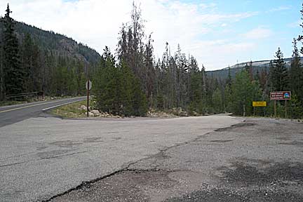
Center Street (Highway 150). Travel east on Highway 150 for 21
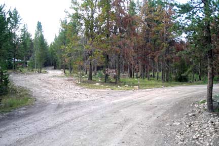
miles. You will see the Murdock Basin Turn off to the right. The road is paved
for the first 200 yards across the bridge over the Provo River. The
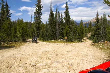
road then turns to dirt. It is about 1.5 miles to the trail head
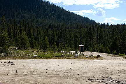
parking. Before the trail head there is a fork to the left that
goes to Broadhead Meadows. There is a restroom and plenty of
parking at the trailhead. Murdock Basin is in the Uinta National Forest off of the Mirror
Lake Highway Road east of Kamas. It is 75 miles from my house
in the Salt Lake Valley. To get there from the Salt Lake
Valley, Take I-80 east, up Parleys Canyon. At the Silver Creek
Junction take Highway 40 south. At the Keetly Junction (second
Exit) go east on Highway 248 to Kamas. At the stop light in Kamas
turn left on Main Street. Turn right at the next stop light on
Center Street (Highway 150). Travel east on Highway 150 for 21
miles. You will see the Murdock Basin Turn off to the right. The road is paved
for the first 200 yards across the bridge over the Provo River. The
road then turns to dirt. It is about 1.5 miles to the trail head
parking. Before the trail head there is a fork to the left that
goes to Broadhead Meadows. There is a restroom and plenty of
parking at the trailhead.
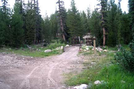
 Don’t take any trailers up the road past
the trailhead or up the Broadhead Meadows road unless you know where
you’re going. Both roads get ruff and very rocky. Don’t take any trailers up the road past
the trailhead or up the Broadhead Meadows road unless you know where
you’re going. Both roads get ruff and very rocky.
Watering Holes:
In Kamas there is a store, gas station and some eating places. I
would recommend the Kamas Cafe.
Camping:
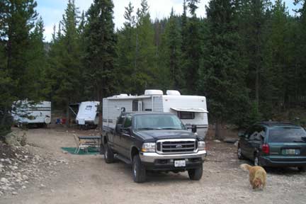 There are many Forest Service Campgrounds on the Mirror Lake
Highway. On the Murdock Road Between the turn off from Highway 150
and the trailhead there are many primitive camping spots. The
forest service just closed 30 or more spots equivalent to a
campground along the road where people had been camping for years on
the old road bed 50 feet off the main road, there reason was to
protect wildlife habitat. Between that road and the next road must
be at least 10 miles of wildlife habitat don’t see why that 50 feet
along the road was hurting it. There are also some primitive
camping spots on both side of the Broadhead Meadows road for the
first 200 yards. These are the best spots I think. Don’t turn onto
that road unless you have walked up it and found a spot. Don’t take
a trailer up the Broadhead Meadows Road unless you know where you’re
taking it. This area is very popular on weekends, but you can
usually find a camping spot. There are many Forest Service Campgrounds on the Mirror Lake
Highway. On the Murdock Road Between the turn off from Highway 150
and the trailhead there are many primitive camping spots. The
forest service just closed 30 or more spots equivalent to a
campground along the road where people had been camping for years on
the old road bed 50 feet off the main road, there reason was to
protect wildlife habitat. Between that road and the next road must
be at least 10 miles of wildlife habitat don’t see why that 50 feet
along the road was hurting it. There are also some primitive
camping spots on both side of the Broadhead Meadows road for the
first 200 yards. These are the best spots I think. Don’t turn onto
that road unless you have walked up it and found a spot. Don’t take
a trailer up the Broadhead Meadows Road unless you know where you’re
taking it. This area is very popular on weekends, but you can
usually find a camping spot.
Riding
There are two main riding areas in Murdock Basin, the Murdock
Road east of the trailhead and the Broadhead Meadows area. You can
describe these trails with one word “ROCKY”.
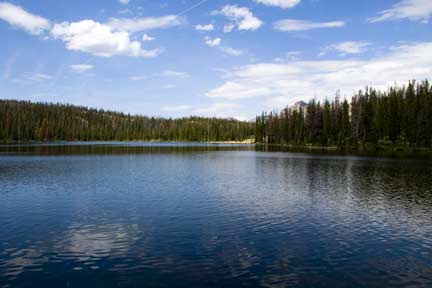
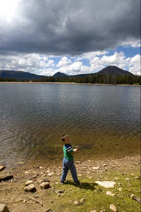
East from the trailhead on the Murdock Road you have a group of
lakes with fish in them, which you can drive your ATV to within a
few 100 feet of them. There are also some dead end roads and two
loop trails. There are two ATV width trails River Run and Drop
Off. The road is very rocky but offers some beautiful
vistas and lakes. The last lake on the road has water lilies in
it. The road at the very end turns into the River Run trail
and loops around and connects at about the
Marshall Lake Turn off. The other loop trail Drop Off comes out at the
trailhead; it is steep and is a rock crawlers dream.
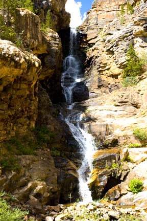 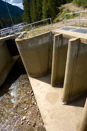
There is also a
road down to the Duchesne River, where there is a beautiful
waterfall and the start of the Duchesne Tunnel. You can also fish
the Duchesne River. This road is also very rocky.
This is the turn off to the Broadhead Meadows
which has two loop trails that are very rocky. One
is called Broadhead Loop and the other is Ritter Loop below.
There is
also a road that connects to Highway 150 just below Trial Lake. On
the Ritter Loop you will go past Lost Lake which has fish in it.
 This trail also goes by some old saw mill areas and there are also
some very rocky sections. The Broadhead Loop Trail is very rocky
and it like rock crawling for miles. I have been on it once and
probably will now go on it again.
This trail also goes by some old saw mill areas and there are also
some very rocky sections. The Broadhead Loop Trail is very rocky
and it like rock crawling for miles. I have been on it once and
probably will now go on it again.
Winter Riding
The Mirror Lake Highway 150 is groomed in the
winter and is a snowmobile trial all the way to East Fork of the
Bear. The Mirror Lake highway is plowed to the Soapstone Basin.
There is a parking lot right on the Highway 150 and a restroom. You
can ride up the road but I wouldn’t get off the groomed trail
without a shovel and a case of power bars. Murdock Basin road is
not groomed.
GPS
Murdock Basin Turnoff N40°37.064 W110°57.854 Altitude
8724. Murdock Basin Trailhead N40°38.124 W110°56.448 Altitude
9301 Water Fall N40°37.320 W110°53.498 Altitude
8179 Pyramid Lake N40°39.318 W110°53.910 Altitude
9744 Broadhead Meadows turnoff of Murdock Road N40°38.127 W110°56.518 Altitude
9202 Broadhead Meadows loop turnoff N40°38.367 W110°55.983 Altitude
9531 Ritter Fork N40°38.605 W110°55.978 Altitude
9485 Lost Lake N40°40.435 W110°56.142 Altitude
9875 Broadhead Meadow road and Highway 150 below Trial Lake
N40°39.766 W110°56.783 Altitude
9560 Turnoff to Lost Lake N40°39.572 W110°56.487 Altitude
9636
|